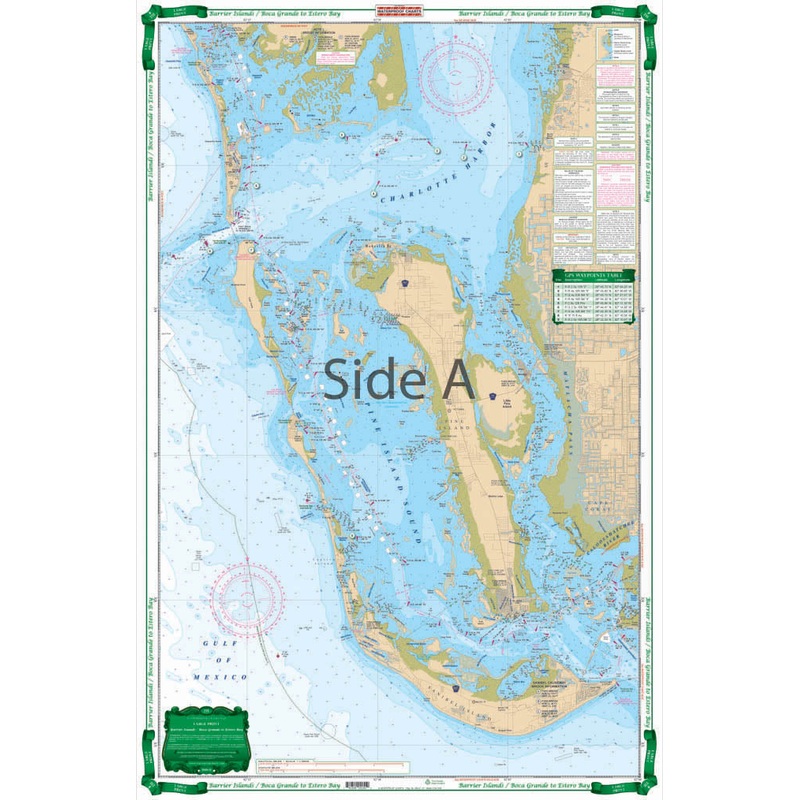
Very easy to read large print coverage of Charlotte Harbor, Pine Island Sound, and Matlacha Pass including all of Sanibel. Offshore up to 6 miles. The reverse side is from Ft. Myers Beach and Sanibel up the river to Cape Coral, Ft.Myers, and East Ft. Myers
Flash Sale Ongoing
Very easy to read large print coverage of Charlotte Harbor, Pine Island Sound, and Matlacha Pass including all of Sanibel. Offshore up to 6 miles. The reverse side is from Ft. Myers Beach and Sanibel up the river to Cape Coral, Ft.Myers, and East Ft. Myers. Detail for Estero Bay and Hancock Creek. Large Place Names and added street names in Cape Coral make it very easy to use. Colored Key makes chart easy to understand. A total of 13 plotted and indexed GPS Waypoints. Dont think of going out on the water without this Barrier Islands map. The detail and vibrant colors make it perfect for on-the-water use, as well as a handsomely framed piece of art for your office or home wall. Very easy to read large print coverage of Charlotte Harbor, Pine Island Sound, and Matlacha Pass including all of Sanibel. The navigation map doesnt just hug the shore, it runs offshore up to 6 miles. The reverse side is from Fort Myers Beach and Sanibel up the river to Cape Coral, Fort Myers, and East Fort Myers. Details are included for Estero Bay and Hancock Creek. Large place names and added street names in Cape Coral make it very easy to use, you will know exactly where you are and where youre going. The colored key makes this nautical map easy to understand.
Reviews
There are no reviews yet.