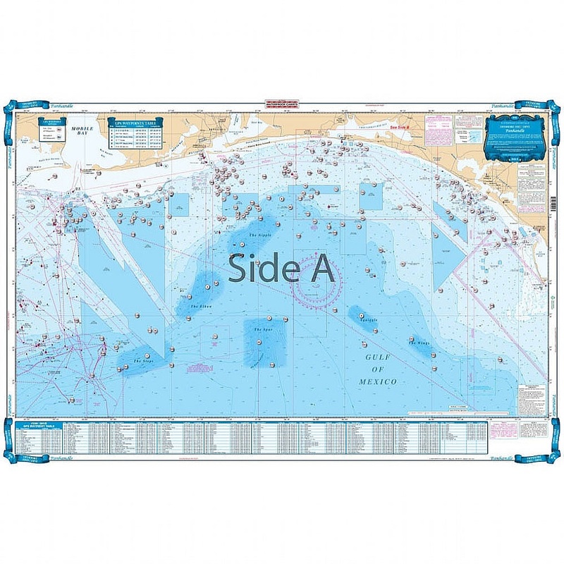
Offshore coverage from Cape San Blas west to Dauphin Island, Alabama and south to 29 degrees north latitude (77 miles south of Destin). Features enhanced bathymetric contour lines in famous Billfish areas; "The Nipple, "The Spur, "The Steps, "The Elbow, "D
Flash Sale Ongoing
Offshore coverage from Cape San Blas west to Dauphin Island, Alabama and south to 29 degrees north latitude (77 miles south of Destin). Features enhanced bathymetric contour lines in famous Billfish areas; “The Nipple, “The Spur, “The Steps, “The Elbow, “Desoto Canyon, and others with GPS coordinates. The reverse side covers the coastal area from 20 miles east to 12 miles west of Destin and up to 22 miles offshore (200 depth) and features enhanced contours, numerous marked fishing areas and large areas of coral bottoms for fishing and diving. A total of 265 plotted GPS Waypoints for reefs and wrecks, coral areas, ledges, artificial reefs, fishing, and diving locations. This Florida panhandle map offers tons of hot spots for catching fish. This fishing chart provides offshore coverage that runs from Cape San Blas west to Dauphin Island Alabama and south to 29 degrees north latitude (77 miles south of Destin). This Florida fishing marine map features enhanced bathymetric contour lines in famous Billfish areas; “The Nipple, “The Spur, “The Steps, “The Elbow, “Desoto Canyon, and others with GPS coordinates. The reverse side covers the coastal area from 20 miles east to 12 miles west of Destin and up to 22 miles offshore (200 depth) and features enhanced contours, numerous marked fishing areas and large areas of coral bottoms for fishing and diving. A total of 265 plotted GPS Waypoints for reefs and wrecks, coral areas, ledges, artificial reefs, fishing, and diving locations. This navigation chart will look amazing once framed and displayed in your home or office.
Reviews
There are no reviews yet.